Ho & Volta region info - Tourism. Pictures. Travel Advise. ( & Deutsch)
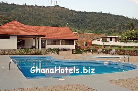
Picture: Part of Chances Hotel in Ho. Recommended accommodation, modern, traditional, restaurants and swimming pools, gym, conference rooms...
|
Woezor in Ho! Welcome in Ho!
Ho is the administrative capital for the Volta Region of Ghana Ho is a city in south east Ghana and is the capital of the Volta Region. It lies near Mount Adaklu and is home to a museum, a cathedral and a large prison. The language spoken is mainly Ewe. Ho is originally made up of the villages of Bankoe, Dome, Ahoe, Hliha and Heve. Later on suburbs such Fiave, Deme - originally part of Taviepe in the Ho municipality, begun to develop. |
Ho is noted for a lively and huge open market that attracts people from all over Ghana and Togo. Ho is also home to few internet cafes. The connections are sometimes a bit "shaky".
There are numerous churches, include a Catholic cathedral located in the center of town.
There are many food spots and restaurants, including a particularly lovely establishment called the White House.
* Deutsch: Bitte unterhalb lesen!
There are numerous churches, include a Catholic cathedral located in the center of town.
There are many food spots and restaurants, including a particularly lovely establishment called the White House.
* Deutsch: Bitte unterhalb lesen!
|
The Ho Municipality is the largest urban centre in the region and in the southeast of Ghana, near Mount Adaklu.
Once part of the German colony of Togoland, then occupied by the British, the country finally gained independence in 1957. Ho itself is safe town, enveloped by a lush, mountainous surrounding area, and well-known for a lively and huge open market that attracts people from all over Ghana and Togo. There are a few internet cafes, numerous churches and restaurants, and a town that feels like a huge village. The Ho District shares boundaries with the North Tongu and Akatsi Districts to the South and Hohoe District to the north. Kpando District is to the west, while the Republic of Togo is to the east. The region’s population in 2000 was 1,635,421. Per square kilometre; 79.5 persons in 2000. The Regional Minister Voltal Regional Coordinating Council P. O. Box 119, Ho Voltal Region Ghana, West Africa Tel: (+233 91) - 28301/28318/28303/28103 Fax: (+233 91) - 27093/27095 |
|
|
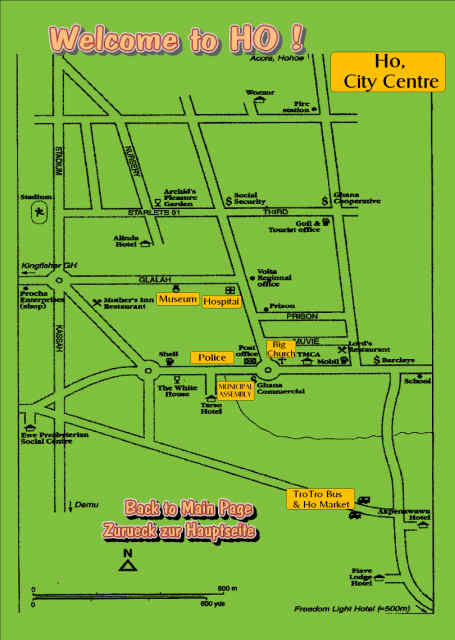
Ho - Ho Municipal District (and capital)
Volta region accommodation. Hotels and Guesthouses.
|
Advertisement

Recommended: the Volta Regional Museum in Ho. Beside changing exhibitions, you`ll find there a SWORD exhibition. Lovely museum. The museum was established more than 40 years ago, to show-case Ghanaian and African culture and arts.
There is a small entrance fee to pay. Daily open, near Ho general hospital. |
Attractions & Excursions in the Volta Region - See here even more Volta tourism links
River Volta Estuary
The estuary is an area of great scenic beauty, with river and ocean beaches, and picnic spots shaded by palm trees. The sand bars are the nesting grounds for sea birds, and endangered species of turtle are still found here.
The Keta-Angraw Lagoon Basin
Important wetlands and breeding grounds for migratory birds.
Tafi Monkey Village
The sacred monkey sanctuaries around Tafi Atome, some 5km away the Avatime Hills.
The Waterfalls of the Volta Region
Although some may be seasonal , all are set in attractive wooded or mountain settings.
Wli Falls - 20km from Hohoe, in the Wli Nature Reserve
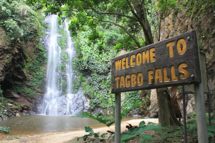
Tagbo Falls - Liate Wote
Tsatsadu Falls - 10km from Hohoe
Aflambo Falls - Leklebi
Amedzofe- Abadzeme Falls
Kalakpe Game Production Reserve
At Abutia Kloe, 15 km from Ho , the reserve has increasing species of migratory and indigenous birdlife , buck, buffalo and monkeys
Kayabobo National Park
A newly designated national park in the foothills of Mt. Djebobo, on the border with Togo
Grottos and Caves
In the limestone hills, the grottos and the caves are dramatic. Not to be missed are:
The ancestral caves of Likpe - 14km from Hohoe
The grottos of Kpando - Agbehoe and Aziavi
The caves of Nyagbo and Logba
Caves and iron mine workings - Alepafu
Historical Sites
Fort Prinsenstein, Keta
Cape St Paul Lighthouse,Woe
German historical sites at Kpando, Ho, Amedzofe, Kpedze
River Volta Estuary
The estuary is an area of great scenic beauty, with river and ocean beaches, and picnic spots shaded by palm trees. The sand bars are the nesting grounds for sea birds, and endangered species of turtle are still found here.
The Keta-Angraw Lagoon Basin
Important wetlands and breeding grounds for migratory birds.
Tafi Monkey Village
The sacred monkey sanctuaries around Tafi Atome, some 5km away the Avatime Hills.
The Waterfalls of the Volta Region
Although some may be seasonal , all are set in attractive wooded or mountain settings.
Wli Falls - 20km from Hohoe, in the Wli Nature Reserve
Tagbo Falls - Liate Wote
Tsatsadu Falls - 10km from Hohoe
Aflambo Falls - Leklebi
Amedzofe- Abadzeme Falls
Kalakpe Game Production Reserve
At Abutia Kloe, 15 km from Ho , the reserve has increasing species of migratory and indigenous birdlife , buck, buffalo and monkeys
Kayabobo National Park
A newly designated national park in the foothills of Mt. Djebobo, on the border with Togo
Grottos and Caves
In the limestone hills, the grottos and the caves are dramatic. Not to be missed are:
The ancestral caves of Likpe - 14km from Hohoe
The grottos of Kpando - Agbehoe and Aziavi
The caves of Nyagbo and Logba
Caves and iron mine workings - Alepafu
Historical Sites
Fort Prinsenstein, Keta
Cape St Paul Lighthouse,Woe
German historical sites at Kpando, Ho, Amedzofe, Kpedze
Mount Afadzato
At 2905 feet above sea level, Mount Afadzato in Gbledi Gborgame is the highest peak in Ghana. The biodiversity importance of the area is considered exceptional, especially in terms of butterfly and bird species. The site has been selected as one of the key Important Bird Areas in Ghana, based on BirdLife International’s criteria.
There is also evidence that the Afadjato forest is home to some endangered mammals. An example is the Golden Cat, Pro fells aurata, which is known to be extinct in most parts of the country.
Nearby at Amedzofe is Mount Gemi at over 2000 feet above sea level. This is a major attraction for people interested in mountaineering. Just south of Ho and in view of Chances Hotel is Adaklu Mountain, excellent for hiking.
Keta Lagoon
Directly south of Ho lies the Keta Lagoon near the shore of the Atlantic Ocean. The Lagoon Complex is the largest wetlands site in Ghanacovering 1,200 sq. km. from the eastern shores of the Volta River to the border of Togo.
The site covers four districts including South Tongu, Akatsi, Ketu and Keta District Assemblies in the Volta Region. The Complex includes the main Keta Lagoon and a series of smaller lagoons and associated seasonal mudflats.
The Keta Complex, which was established In 1993, supports the largest inland fisheries on the coastal zone of the country. Other principle economic activities within the site are shallot farming through irrigated agriculture and mat, hat and fan weaving from reeds along the lagoon banks. These activities generate income for the local Inhabitants.
The Coastal Wetlands Management Project (CWMP) started in 1993 to address some of the problems of environmental degradation in the coastal zone of Ghana. The project was initiated to implement the recommendations of the Save the Seashore Birds Project (1985-1994) and the Environmental Action Plan of 1990. The project is the first initiative In the country to manage wetland areas within the guidelines of the RAMSAR Convention.
Unlike most other wildlife reserves in the country, the RAMSAR guidelines allow for multiple land use in wetlands.
Eleven species of tern can be found along Ghana’s coast. Four species — common tern, black tern, royal tern and sandwich tern — make up 80 per cent of what can be as many as 50,000 terns. The rare roseate tern makes up only two per cent of this population. In addition, 42 species of wading birds (34 are migratory and 11 occur in internationally important numbers)
make the coast of Ghana a haven for bird life.
At least five species of marine turtle nest in the area at various times of the year:, leatherback (Dermochelys concea); loggerhead (Caretta caretta); olive ridley (LepIdachelys olivacea); hawksbill (Eretomychelys imbricata); and green turtles (Chelonia mydas).
KENTE - from the KPETOE KENE WEAVING VILLAGE
Many collectors regard Ewe textiles as the highest expression of African weaving artistry. The weavers of Kpetoe claim an Akan origin from an area towards the coast near Accra. Although they do supply important regalia to local chiefs, Ewe
weavers work primarily for sale through markets and to fill orders from important local men and women~ Today Ewe weavers are concentrated around two towns, Kpetoe and Agbozume, with the latter the site of a large cloth market
which draws buyers from throughout Ghana as well as neighbouring countries.
Ewe weavers utilise an almost identical form of the narrow-strip loom as that of the Asante, and there is considerable evidence to suggest mutual influence between the weavers of the ....
COLOURFUL FESTIVALS
Throughout Ghana festivals abound at all times of the year, and the Volta is no exception. If you happen to be in the Volta Region at a time when a festival is taking place, we will arrange for you to attend. Festivals commemorate and celebrate many different events in the lives of the Ewe people - from purification rituals and historic events - to puberty rites and harvest time.
These colourful events feature traditional durbars with chiefs, drumming and partying!
The "Hogbetsotso"(Exodus Festival) in Anloga is celebrated on the first Saturday in November to commemorate the successful exodus of the Anlo people from captivity in Notsie,Togo. Participants walk backwards, symbolizing an escape from the clutches of a tyrannical ruler. The ceremony includes a peace-making period where outstanding problems are resolved, a purification of the traditional stool, a period of general cleaning and a durbar where chiefs dress in traditional regalia and sit in state to receive homage from subjects - followed by general merry making and a re-enactment of the exodus.
Brown Rice Festival - The Amu festival was instituted some few years ago, by Osie Adza Tepkor VI, Paramount Chief of Avatime. (Volta region of Ghana)
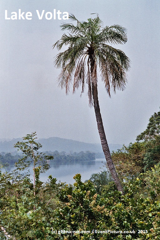
AKOSOMBO DAM AND LAKE VOLTA
The Akosombo Dam across the Volta River was built by Kaiser Aluminum and handed over to the Ghana government under Kwame Nkrumah in 1966. The hydro electric plant generates electricity for most of Ghana plus Burkino Paso and Togo. Visitors can enjoy a spectacular panoramic view from the terrace of the Volta Hotel. Dam site visits can also be arranged.
The Volta Lake Is a man-made lake created after the River Volta was dammed at the Akosombo gorge. The lake is elongated and has a generally north-south orientation with an average length and width of 400 km and 25 km respectively. On Sundays, guests can board the Dodi Island Princess ferry for a cruise on the calm waters of the lake - with entertainment
and lunch on board, and a stop at Dodi Island.
KALAKPA GAME RESERVE
The Kalakpa Game Reserve was established in 1975. The landscape is a mixture of Savannah grassland, riverine woodland, isolated hills covered with dry forest, and extensive growths of borassus palms. To date, 19 species of mammals - including buffalo, red river hog, waterbuck, bushbuck, porcupine, pangolin, several duikers, kob and three species of primates (green monkey, patas and olive baboon) have been sighted in the reserve. The kob antelope has been adopted as the symbol of the reserve.
Kalakpa lies entirely in the territory of the Ho District Assembly. The reserve is drained by the Kalakpa River and its tributaries flow in the rainy season, but dry up from January to May each year. The main aquatic life includes crocodile, soft-shelled turtles and various species of fish. There is also a healthy diversity of bird life. A network of foot paths criss-cross
the reserve, joining the villages around it.
TAFI-ATOME MONKEY SANCTUARY
An hour’s drive from Hohoe lies the Tafi-Atome monkey sanctuary, located 8 km from Logba-Alakpeti on the Accra-Hohoe road. The Mona monkey can be seen here, where they are treated as sacred animals and looked upon as gods. Approximately 150 true Mona monkeys, Cercopithecus mona mona, live in a culturally-protected grove. It is the only completely intact population of the sub-species remaining in Ghana today. The village was selected and won an award as the tourism village of the year in 1997. The community is financing a number of projects with proceeds from visitors. Through continued support from non-government organisations, a restaurant and an Information Centre have been built to cater
for the needs of visitors.
WATERFALLS OF VOLTA REGION
The Wli waterfall in the Hohoe District is Ghana’s highest waterfalL This Is a year round waterfall located in the Wli nature reserve - about 15km from Hohoe. The walk to the falls is about 45 minutes from the town through woods and streams, with
sturdy wooden footbridges crossing a meandering creek at eight different points on route to the waterfall. The mountain from which the water flows is part of the Akwapim-Togo range. It has a colony of wild bats, flowers and butterflies, adding to the
ambiance. Exotic plant species adorn the top of the mountain.
The smaller Tagbo falls are also set deep in a forest some 2km east of Liate-Wote in the Hohoe District. It is extremely beautiful with a small pool.
Other smaller falls include: Alavanyo Tsatsadu Falls - Alavanyo (about 10km from Ilohoe); the Aflambo Falls - Leklebi-Dafor (8km off the Hohoe-Accra road through Golokwati); and Amedzofe-Gbadzeme Falls (50km north of Ho).
At 2905 feet above sea level, Mount Afadzato in Gbledi Gborgame is the highest peak in Ghana. The biodiversity importance of the area is considered exceptional, especially in terms of butterfly and bird species. The site has been selected as one of the key Important Bird Areas in Ghana, based on BirdLife International’s criteria.
There is also evidence that the Afadjato forest is home to some endangered mammals. An example is the Golden Cat, Pro fells aurata, which is known to be extinct in most parts of the country.
Nearby at Amedzofe is Mount Gemi at over 2000 feet above sea level. This is a major attraction for people interested in mountaineering. Just south of Ho and in view of Chances Hotel is Adaklu Mountain, excellent for hiking.
Keta Lagoon
Directly south of Ho lies the Keta Lagoon near the shore of the Atlantic Ocean. The Lagoon Complex is the largest wetlands site in Ghanacovering 1,200 sq. km. from the eastern shores of the Volta River to the border of Togo.
The site covers four districts including South Tongu, Akatsi, Ketu and Keta District Assemblies in the Volta Region. The Complex includes the main Keta Lagoon and a series of smaller lagoons and associated seasonal mudflats.
The Keta Complex, which was established In 1993, supports the largest inland fisheries on the coastal zone of the country. Other principle economic activities within the site are shallot farming through irrigated agriculture and mat, hat and fan weaving from reeds along the lagoon banks. These activities generate income for the local Inhabitants.
The Coastal Wetlands Management Project (CWMP) started in 1993 to address some of the problems of environmental degradation in the coastal zone of Ghana. The project was initiated to implement the recommendations of the Save the Seashore Birds Project (1985-1994) and the Environmental Action Plan of 1990. The project is the first initiative In the country to manage wetland areas within the guidelines of the RAMSAR Convention.
Unlike most other wildlife reserves in the country, the RAMSAR guidelines allow for multiple land use in wetlands.
Eleven species of tern can be found along Ghana’s coast. Four species — common tern, black tern, royal tern and sandwich tern — make up 80 per cent of what can be as many as 50,000 terns. The rare roseate tern makes up only two per cent of this population. In addition, 42 species of wading birds (34 are migratory and 11 occur in internationally important numbers)
make the coast of Ghana a haven for bird life.
At least five species of marine turtle nest in the area at various times of the year:, leatherback (Dermochelys concea); loggerhead (Caretta caretta); olive ridley (LepIdachelys olivacea); hawksbill (Eretomychelys imbricata); and green turtles (Chelonia mydas).
KENTE - from the KPETOE KENE WEAVING VILLAGE
Many collectors regard Ewe textiles as the highest expression of African weaving artistry. The weavers of Kpetoe claim an Akan origin from an area towards the coast near Accra. Although they do supply important regalia to local chiefs, Ewe
weavers work primarily for sale through markets and to fill orders from important local men and women~ Today Ewe weavers are concentrated around two towns, Kpetoe and Agbozume, with the latter the site of a large cloth market
which draws buyers from throughout Ghana as well as neighbouring countries.
Ewe weavers utilise an almost identical form of the narrow-strip loom as that of the Asante, and there is considerable evidence to suggest mutual influence between the weavers of the ....
- KENTE in PICTURES & Info about Volta Kente / (And Pictures!)
- Kente Festival of the Agotime people / (Full Info!)
COLOURFUL FESTIVALS
Throughout Ghana festivals abound at all times of the year, and the Volta is no exception. If you happen to be in the Volta Region at a time when a festival is taking place, we will arrange for you to attend. Festivals commemorate and celebrate many different events in the lives of the Ewe people - from purification rituals and historic events - to puberty rites and harvest time.
These colourful events feature traditional durbars with chiefs, drumming and partying!
The "Hogbetsotso"(Exodus Festival) in Anloga is celebrated on the first Saturday in November to commemorate the successful exodus of the Anlo people from captivity in Notsie,Togo. Participants walk backwards, symbolizing an escape from the clutches of a tyrannical ruler. The ceremony includes a peace-making period where outstanding problems are resolved, a purification of the traditional stool, a period of general cleaning and a durbar where chiefs dress in traditional regalia and sit in state to receive homage from subjects - followed by general merry making and a re-enactment of the exodus.
Brown Rice Festival - The Amu festival was instituted some few years ago, by Osie Adza Tepkor VI, Paramount Chief of Avatime. (Volta region of Ghana)
AKOSOMBO DAM AND LAKE VOLTA
The Akosombo Dam across the Volta River was built by Kaiser Aluminum and handed over to the Ghana government under Kwame Nkrumah in 1966. The hydro electric plant generates electricity for most of Ghana plus Burkino Paso and Togo. Visitors can enjoy a spectacular panoramic view from the terrace of the Volta Hotel. Dam site visits can also be arranged.
The Volta Lake Is a man-made lake created after the River Volta was dammed at the Akosombo gorge. The lake is elongated and has a generally north-south orientation with an average length and width of 400 km and 25 km respectively. On Sundays, guests can board the Dodi Island Princess ferry for a cruise on the calm waters of the lake - with entertainment
and lunch on board, and a stop at Dodi Island.
KALAKPA GAME RESERVE
The Kalakpa Game Reserve was established in 1975. The landscape is a mixture of Savannah grassland, riverine woodland, isolated hills covered with dry forest, and extensive growths of borassus palms. To date, 19 species of mammals - including buffalo, red river hog, waterbuck, bushbuck, porcupine, pangolin, several duikers, kob and three species of primates (green monkey, patas and olive baboon) have been sighted in the reserve. The kob antelope has been adopted as the symbol of the reserve.
Kalakpa lies entirely in the territory of the Ho District Assembly. The reserve is drained by the Kalakpa River and its tributaries flow in the rainy season, but dry up from January to May each year. The main aquatic life includes crocodile, soft-shelled turtles and various species of fish. There is also a healthy diversity of bird life. A network of foot paths criss-cross
the reserve, joining the villages around it.
TAFI-ATOME MONKEY SANCTUARY
An hour’s drive from Hohoe lies the Tafi-Atome monkey sanctuary, located 8 km from Logba-Alakpeti on the Accra-Hohoe road. The Mona monkey can be seen here, where they are treated as sacred animals and looked upon as gods. Approximately 150 true Mona monkeys, Cercopithecus mona mona, live in a culturally-protected grove. It is the only completely intact population of the sub-species remaining in Ghana today. The village was selected and won an award as the tourism village of the year in 1997. The community is financing a number of projects with proceeds from visitors. Through continued support from non-government organisations, a restaurant and an Information Centre have been built to cater
for the needs of visitors.
WATERFALLS OF VOLTA REGION
The Wli waterfall in the Hohoe District is Ghana’s highest waterfalL This Is a year round waterfall located in the Wli nature reserve - about 15km from Hohoe. The walk to the falls is about 45 minutes from the town through woods and streams, with
sturdy wooden footbridges crossing a meandering creek at eight different points on route to the waterfall. The mountain from which the water flows is part of the Akwapim-Togo range. It has a colony of wild bats, flowers and butterflies, adding to the
ambiance. Exotic plant species adorn the top of the mountain.
The smaller Tagbo falls are also set deep in a forest some 2km east of Liate-Wote in the Hohoe District. It is extremely beautiful with a small pool.
Other smaller falls include: Alavanyo Tsatsadu Falls - Alavanyo (about 10km from Ilohoe); the Aflambo Falls - Leklebi-Dafor (8km off the Hohoe-Accra road through Golokwati); and Amedzofe-Gbadzeme Falls (50km north of Ho).
Deutsch Togoland / Volta Region / British Gold Coast (Engl. & Deutsch)
Ho is a city in southeast Ghana and is the capital of the Volta Region. It lies near Mount Adaklu and is home to a museum, a cathedral a large prison and a very interesting market. The language spoken is mainly Ewe.
Ho ist eine Stadt im Suedosten Ghanas und die Hauptstadt der Voltaregion. Die Stadt befindet sich in der Naehe des Berges Adaklu und ist Heimat fuer das Volta Regional Museums , einer Katedrale, einem grossen Gefaengnis und einem sehr interessanten Markt. Die hauptsaechliche Sprache ist Ewe. (neben Englisch)
The city arose from the union of the villages of Bankoe, Dome, Ahoe, Hliha and Heve. Later on, suburbs such Fiave, Deme *originally part of Taviepe, also in the Ho municipality) began to develop.
Die Stadt bildete sich aus den Doerfern Bankoe, Dome, Ahoe, Hliha und Heve. Spaeter kamen ortschaften, wie Fiave, Deme *urspruenglich Teil von Taviepe, hinzu.
Ho was a part of the German colony of Togoland until World War I when it was occupied by the British.
Ho war einst teil der deutschen Kolonie Togoland. Im ersten Weltkrieg wurde das gebiet von britischen Truppen
eingenommen.
Ho later became the capital of the League of Nations mandate of British Togoland (1923) until that entity's incorporation into the British Gold Coast colony, which subsequently became Ghana.
Ho wurde die Haupstadt von Britisch Togoland (1923) ,bis zur voelligen "Integration" in Britisch Gold Kueste,
welches 1957 die Republik Ghana wurde.
The city is home to three hospitals, including the Volta Regional Hospital, completed in the year 2000 with a loan from the British Government. There are also numerous clinics available in the city.
Die Regional Hauptstadt verfuegt ueber drei Krankenhaeuser (u.a. das VoltaRegional Krankenhaus, welches 2000 mit britischer Finanzunterstuetzung fertiggestellt wurde. Sie finden zahlreiche weitere private Arztpraxen.
Ho is noted for a lively and huge open market that attracts people from all over Ghana and Togo. There are numerous churches, including the cathedral of the Roman Catholic Diocese of Ho.
Ho ist bekannt fuer einen lebhaften und offenen Markt, welcher Anziehungspunkt fuer Kaefer und Haendler von ganz Ghana und Togo ist. Sie finden zahlreiche Kirchen, u.a. die katholische Kathedrale.
Togoland
Schutzgebiet Togo / Togoland protectorate / Protectorate of Germany
1884-1914 (1923)
Togoland
Capital Bagida (1884-86)
Hauptstadt Bagida, danach
Sebeab (1886-97)
Lomé (1897- )
Language(s) German
Sprache(n) Deutsch
- Protectorate established July 5, 1884
-Schutzgebiet ab 5.7.1884
- Allied occupation August 26, 1914
-Besetzung durch die "Alliierten" am 26.August 1914
- Togoland partitioned December 27, 1916
Aufgteilt am 27.12.1916
Currency German gold mark
Waehrung war die Gold Mark
Togoland was a German protectorate in West Africa from 1884 to 1914. The protectorate was established during the "Scramble for Africa", when German explorer and imperialist Gustav Nachtigal arrived at Togoville, sent as a special commissioner by Prime Minister Otto von Bismarck. On July 5, 1884, a treaty was signed with the local chief, Mlapa III, in which the German Empire declared a protectorate over a stretch of territory along the coast of the Bight of Benin. Nachtigal was Reichskommissar for a day, but was replaced on July 6 by Heinrich Randad as other tasks were waiting for Nachtigal in Northern Africa.
Togoland war von 1884 bis 1914 , ein deutsches "Schutzgebiet" in Westafrika. Das Schutzgebiet wurde errichtet , waehrend der "Aufteilung" Afrikas . Der deutsche Erforscher Gustav Nachtigal wurde als besonderer Botschafter von dem deutschen Regierungsoberhaupt Otto von Bismarckesand nach Togoville gesand.
Am 5.July 1884 wurde eine Vereinbarung , mit dem lokalen Koenig Mlapa III , unterzeichnet.
Dieser Vertrag erklaerte das deutsche Reich als Schutzmacht ueber das Gebiet ( Heute Togo und Volta Region im heutigen Ghana zusammengenommen.)
Germany gradually extended its control inland. They brought scientific cultivation to the country's main export crops (cacao, coffee and cotton) and developed its infrastructure to one of the highest levels in Africa. Because it became Germany's only self-supporting colony, Togoland was known as its model possession. This would last until the eruption of World War I.
Deutschland erweiterte die Kontrolle in das Hinterland. Es wurde eine fortschrittliche Anbaummassnahmen fuer die hauptexportgueter Kakao, Kaffe, und Baumwolle) getroffen. Die Infrastruktur entwickelte sich zu einer der besten in Afrika. Deutsch Togoland wurde eine wirtschaftlich unabhaengige Kolonie und ein Modellbeispiel, bis zum Ausbruch des 1.Weltkrieges.
After calling on German forces to surrender on 6 August 1914, French and British forces invaded the colony the next day, occupying Lome and advancing on a powerful radio station near Kamina (just east of Atakpamé). The colony surrendered on August 26, after the Germans had destroyed the station on the night of August 24/25. On December 27, 1916, Togoland was divided into French and British administrative zones. Following the war, Togoland formally became a League of Nations Class B mandate divided for administrative purposes into French Togoland and British Togoland (covering respectively about 2/3 and 1/3 of the territory).
Es erfolgte ein Aufruf an die deutschen Truppen zu kapitulieren ( 6. August 1914 ). Franzoesische und Britische Truppen marshierten am naechsten Tage ein und besezten Lome.
Das Zielweitreichende; eine Radio Station in der Naaehe von Kamina.
Die Kolonie kapitulierte schliesslich am 26. August, nachdem die Deutschen die Radiostation in der Nacht vom 24. zum 25. August, zerstoert hatten..
Am 27. Dzember 1967 wurde Togoland in einen franzoeschen und eine britschen Verwaltungsbereich unterteilt.
Nach dem Krieg offiziell Verwaltungsgebiet des Voelkerbundes.
As a result, the French-ruled part of Togoland became what is now Togo,
with the rest transferred to Ghana following a plebiscite.
Als ein Ergebnis hieraus wurde ein Teil deutsch Togolands franzoesiche Kolonie (das heutige Togo)
Der Rest wurde spaeter ein Teil der Republik Ghana
British Togoland
British Togoland was a League of Nations Class B mandate in Africa, formed by the splitting of German protectorate Togoland into French Togoland and British Togoland. Its capital was Ho.
The territory of British Togoland was first formed after a partition of Togoland on December 27, 1916,
during World War I. British and French forces already occupied Togoland.
After the war, on July 20, 1922, the League of Nations gave its mandate to formally transfer control of British Togoland to the United Kingdom.
Britisch Togoland
Britisch Togoland wurde ein Verwaltungsgebiet des Voelkerbundes. ( vormaliges deutsch Togoland und nun Franzoesisch und Britisch Togoland. Die Hauptstadt wurde Ho.
Am 20 Juli 1922 erhielt Gross Britannien formell die "Erlaubnis" vom Voelkerbund fuer die "Integrative Verwaltung" in die Britische Goldkueste.
After World War II, the mandate became a UN trust territory administered by the United Kingdom. During the mandate and trusteeship periods, British Togoland was administered as part of the adjoining territory of the Gold Coast, under the name of Trans-Volta Togo (TVT).
Nach dem 2.Weltkrieg wurde das Gebiet ein UN Vertrauensgebiet, verwaltet durch Gross Britannien unter dem Namen "Trans Volta Togo" (TVT).
In 1954, the British government informed the UN that it would be unable to administer the Trust Territory after Ghanaian independence.
In response, in December 1955, the UN General Assembly passed a resolution advising the British government to hold a plebiscite on the future of British Togoland.
Im Jahre 1954 informierte die britische Regierung die UN, dass es unmoeglich waere das Vertrauensgebiet weiterhin zu verwalten, nach einer Unabhaengigkeit Ghanas.
Als Reaktion 1955 darauf, die UN - Sekrtariat forderte Gross Britannien zu einer Abstimmung ueber die Zukunft von Britisch Togoland auf.
On May 9, 1956, this election was held under UN supervision, and 58% of registered voters opted for formal integration into an independent Gold Coast.
On December 13 1956, this unification was put into effect, creating a single entity that became the new independent nation of Ghana on March 6 of the following year.
(from Wikipedia)
Am 9. Mai 1956 wurden Abstimmungwahlen (unter Aufsicht der UN) gehalten. 58% der registrierten Waehler stimmten fuer einen Anschluss an die "Goldkueste", wenn diese unabhaengig bekaeme.
Am 13. Dezember 1956 wurde diese Absimmung gueltig und am 6.Maerz 1957 wurde die Voltaregion ein teil der neugegruendeten,unabhaengigen Republik Ghana.
German Text / Deutscher Text (c) Ghana-Net.com
Advertisement
Search 3 of our sites: ghana-net.com, ghananet.co.uk and ghanawebnews.online
|
Search ghana-net.com OR ghanaweb-news.com (ONLY)
Radio Live Pages |
Ghana Info Pages |
More Ghana Links
British Gold Coast (Many pictures shown!)
Fort Batenstein (full info website) Logbuch.Ghana-net.net (Deutsch) GhanaHotels.biz (400 + Hotels) All Towns of Ghana, by Region A - Z Preventive child health inequality 1283 private health institutions in Ghana |
Welcome to Ghana! Akwaaba!
Ghana-Net.com is one of Ghana`s oldest websites, with tourism information`s about Ghana, Live Radio, life and culture of of all Ghana Nation`s, and tribes - like Ga people, Fante, Ewe, Ashanti, Dagbani, Frafra, Krobo and many other tribes and kingdoms of Ghana.
Ghana-Net.com 1st time online late December 2000, and updated since 2001 !
Ghana-Net.com - connected with; GhanaRadio.online /
GhanaMirror.com / GhanaWeb-News.com / GhanaMirror.uk / GhanaHotels.biz / GhanaFlights.info /
GhanaMirror.com / GhanaWeb-News.com / GhanaMirror.uk / GhanaHotels.biz / GhanaFlights.info /
Privacy Policy, Terms & Conditions and Disclaimer / Services / Contact Us / (c) by ghana-net.com 2000- 2019