Welcome to the Beposo Bridge
Akwaaba!
Twi (Akan) · “Welcome”
Search our Network. Start here.
Ghana-Net.com · River Pra · Central and Western Region · filmed 2026
Thousands of drivers cross the River Pra at Beposo every day on the coast road between Cape Coast and Takoradi, and most of them never look to the side. Right next to them hangs a piece of Gold Coast history: a steel suspension bridge, finished in 1934, that carried the coast road for decades before a new bridge replaced it. Today it is used by people on foot and on motorbikes. And beneath it runs a river that tells a far less romantic story.
Beposo Bridge at a glance
The Pra is one of the great rivers of southern Ghana. It rises far inland, flows through Ashanti and the forest belt, and reaches the sea at Shama, where the Portuguese built Fort San Sebastian centuries ago. For most of history, crossing it near the coast meant canoes and ferries. A permanent crossing at Beposo, completed in 1934, changed that: the coast road between Cape Coast and Sekondi-Takoradi could now run without interruption.
The bridge is a suspension bridge in the classic style of its time: steel towers on both banks, main cables sweeping between them, and a deck hung from vertical hangers, all held together with rivets. For decades it carried lorries, mammy wagons, buses and cars, and with them the trade of the coast: timber, cocoa, fish and people on the move between the Central and Western Regions.
As traffic grew heavier, the old bridge reached its limits. In 1989 JICA, the Japan International Cooperation Agency, published a basic design study for reconstructing the Beposo bridge. The modern road bridge that carries today's traffic stands right beside the old one, and the two can be seen side by side.
"Beposo London Bridge": that is what some Ghanaians call the old bridge, after its towers and hanging cables. It is an affectionate name, though the bridge itself has received little affection in the way of maintenance.
The old bridge was never torn down. It is still in daily use, by people walking between the two banks and by motorbikes. Cars and lorries no longer cross it: the road layout was changed when the new bridge opened, and heavy vehicles simply cannot get onto it any more.
Up close, its age shows. Rust has eaten into the steelwork, and there is little sign of regular care. In 2022 a video of the rusting bridge went viral on Ghanaian social media, and with it the colour of the water beneath. Many viewers were shocked by both.
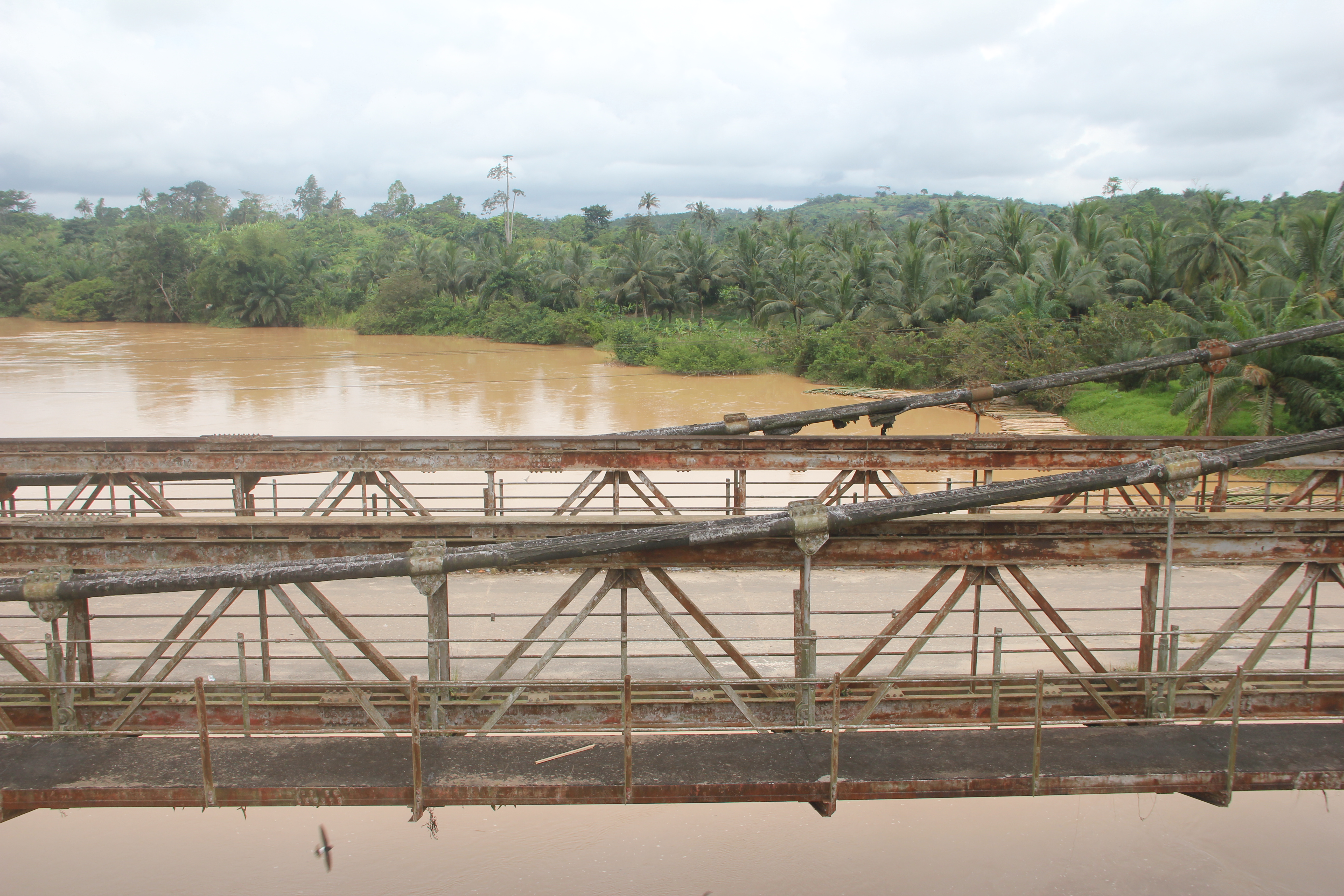
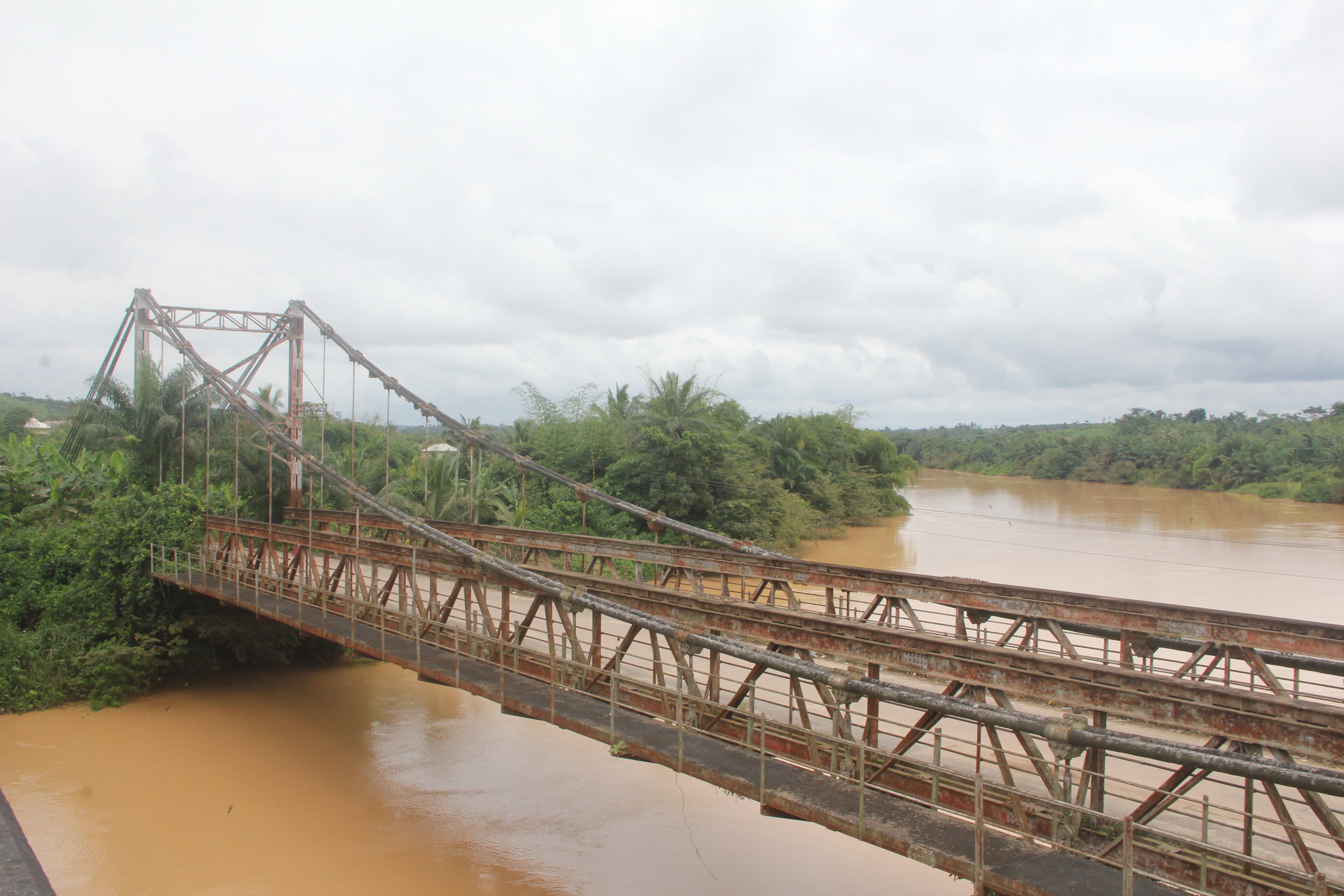
Stand on either bridge and look down. The Pra at Beposo is not the green or dark river it once was. It is brown, thick with sediment, the colour of milky coffee. The cause is upstream: galamsey, illegal small-scale gold mining, which has torn open riverbanks and riverbeds along the Pra and its tributaries for years.
The damage goes far beyond the colour. Excavators dig out the banks; mud and silt choke the water; mercury and other chemicals used to separate the gold enter the river. Farms along the banks are lost, fish disappear, and water treatment plants struggle or shut down because the water is too dirty to clean. Communities that once drank, washed and fished in the Pra now live beside a river that can make them ill. And for tourism, a brown river under a historic bridge is not the picture anyone wants to sell.
Promises and the river
Galamsey is not new. It was already a growing concern under President John Evans Atta Mills around 2009 and 2010. Since then it has expanded dramatically, and every government has promised to stop it. During the 2024 election campaign, John Mahama again pledged to deal with the problem if elected.
In 2026, the river beneath Beposo is still brown. Questions such as who owns the excavators that keep arriving at the harbour remain unanswered. The water is the simplest measure of whether promises are kept.
Read our reporting: the galamsey and water series on GhanaWeb-News.com, including the excavator serial numbers and the river water crisis.
The bridge lies on the main coast road (N1) between Cape Coast and Takoradi, at Beposo near Shama. From Takoradi it is roughly half an hour by car; from Cape Coast a little under an hour, depending on traffic.
Any tro-tro running between Cape Coast or Elmina and Takoradi passes over the new bridge. Ask to be dropped at Beposo.
You can walk across the old bridge, as local people do every day. Watch your step on the deck, keep clear of passing motorbikes, and take care with children.
The best view of both bridges together is from the banks or from the new bridge, but be careful near highway traffic.
The bridge is a public crossing, not a staged attraction. Ask before photographing people, and do not climb on the structure.
There is no entrance fee and no visitor centre: just the bridge, the river and the people who use them.
Guided tours along the coast combine Cape Coast, Elmina and the western forts, and pass Beposo on the way. Entrance fees are included in the tour price; tips are not included, but always welcome.
Looking for a longer journey? Explore the Ghana Gateway Experience 360: curated tours from the castles of Cape Coast and Elmina to Accra and beyond, with instant confirmation and free cancellation up to 24 hours before most experiences.
Beposo sits between two of Ghana's great coastal stretches. Stop here on your way west to Takoradi and Nzulezo, or east to Elmina and Cape Coast.
Yes. The old suspension bridge is used every day by pedestrians and motorbikes. Cars and lorries can no longer reach it since the road was realigned for the new bridge.
It was completed in 1934, during the Gold Coast colonial era, and carried the coast road between Cape Coast and Takoradi for decades.
The new road bridge stands beside the old one. A basic design study for reconstructing the Beposo bridge was published in 1989 by JICA, the Japan International Cooperation Agency.
Mainly because of galamsey, illegal gold mining upstream, which churns up riverbanks and riverbeds, fills the water with silt and introduces chemicals such as mercury.
No. The bridge is a public crossing, open at all times, with no fee and no visitor centre.
Updated and fact-checked: 19 October 2026. Video and photographs: Remo Kurka, 2026. The 1989 reconstruction study is listed in JICA's report archive.
