Welcome to Nzulezo
Akwaaba!
Twi (Akan) · “Welcome”
Search our Network. Start here.
Ghana-Net.com · Western Region · Jomoro · checked October 2026
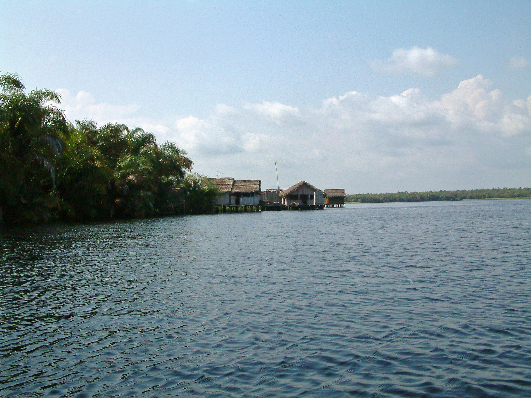
There is no road to Nzulezo. You leave the car at Beyin on the far western coast, climb into a dugout canoe, and glide for the better part of an hour through raffia palms, swamp forest and open water. Then the village rises out of the lake: wooden houses on stilts, joined by plank walkways, with a school, a church and a few hundred people who have lived like this for generations. It is one of the most remarkable places in Ghana, and also one of the most remote.
Nzulezo at a glance
Nzulezo stands at the edge of Lake Tadane, part of the Amansuri wetland that stretches inland behind the coast between Axim and the border with Côte d'Ivoire. It is often described as a village "in the middle of the lake", but that is not quite right. The houses stand on stilts in the water along the lake's edge, where the swamp forest meets open water. What makes it unique is not distance from the shore, but the fact that there is no way to reach it on foot or by car. Everything arrives by canoe: people, food, building timber, fuel, school books, and visitors.
The houses are built of wood and raffia on stilts driven into the lake bed. A main walkway runs through the village like a high street, with narrower planks branching off to homes, the school, the church and the community hall. Below the walkways, canoes are tied up the way cars are parked elsewhere.
The people of Nzulezo tell that their ancestors came from Oualata, a trading city of the ancient Ghana Empire in what is today Mauritania, more than two thousand kilometres away. On their long migration south, so the story goes, they were led by a snail, and where the snail stopped, at the water's edge, they settled.
The snail is still the village totem and is treated with respect. Another explanation, given alongside the legend, is a practical one: a settlement on the water was easier to defend in times of war and raids. Both belong to the oral history of the community; neither has been confirmed by written sources.
Tradition, not documentation: the migration from Oualata and the snail are the community's own account of its origins, passed on by word of mouth. They are told here as such. The link to the old Ghana Empire, from which modern Ghana took its name in 1957, is part of what makes the story so powerful.
Half of the experience is getting there. From the visitor centre at Beyin, the canoe follows narrow channels through raffia palms and swamp forest, among the largest remaining stretches of this kind of forest in Ghana, before the water opens out into the lake. With paddles the trip takes 45 minutes to an hour; motorised canoes are faster.
Look out for kingfishers, herons and egrets, and listen for monkeys in the trees. In the rainy season, roughly May to August, the water is high, the canoe can go all the way, and there is more wildlife to see. In the dry season the water at the start is often too low, and the first stretch, about a kilometre, is a walk along a path before you get into the canoe.
Nzulezo is not a museum. It is a living community, and that is both its charm and its challenge. Children paddle to school, women wash and cook on the platforms, men fish and farm on land around the lake. Baptisms, weddings and funerals all take place on the water.
The main walkway, the school and the church, the community hall, homes with their canoes moored below, and a shrine that only the chief may enter. Villagers sell small carved canoes as souvenirs.
Isolation has a price. Health care is limited, malaria is a constant threat, and power and clean water are long-standing problems. Every supply has to come by canoe.
Visitor fees and sales are an important income for the village. Tourism helps keep Nzulezo alive, but it also changes it. Visit with that in mind.
Nzulezo was placed on Ghana's UNESCO Tentative List in 2000, recognised as one of the few remaining traditional settlements on stilts in the world, with a living culture tied to the lake. Many websites call it a "World Heritage Site". It is not. A Tentative List is a country's list of sites it may one day nominate; more than a quarter of a century later, Nzulezo has not been inscribed.
That is not a judgement on the village. It is a reminder of how slowly heritage nominations move, and how little a listing alone does for the people who live there.
More: Ghana's UNESCO World Heritage Sites, inscribed and tentative
From Takoradi: about 90 km west, roughly 2 hours by car, via Agona Nkwanta and the coast road towards Elubo. Turn off for Beyin and follow the signs to the visitor centre.
By public transport: tro-tros from Takoradi run west towards Elubo and Half Assini. Ask for Beyin, then take a taxi or motorbike to the visitor centre.
From Accra: 6 to 7 hours. Do not try it as a day trip; stay in Takoradi, Axim or Beyin.
Pay the fee for the canoe trip and guided tour up front at the office in Beyin. Fees change, so ask for the current price, and bring cash in cedis.
Canoes usually go out only when full and come back only when full. On a busy day that means waiting. Start early, ideally leaving Takoradi around 7 am.
A villager, often your canoe guide, will walk you around. Ask before you photograph people, especially children and elders, and respect the places you are told not to enter.
Buying a carved canoe or a drink in the village puts money straight into the community.
What to bring
Staying overnight
Basic guesthouse rooms are available in the village itself, for those who want to see Nzulezo after the day visitors have left. More comfortable lodges and beach resorts are in and around Beyin.
The full visitor guide
History, photographs and everything you need for your visit: nzulezo.ghana-net.com.
A guided tour is the easiest way to reach Nzulezo and the forts of the western coast without worrying about transport. Entrance fees are included in the tour price; tips are not included, but always welcome.
Looking for a longer journey? Explore the Ghana Gateway Experience 360: curated tours from the castles of Cape Coast and Elmina to Accra and beyond, with instant confirmation and free cancellation up to 24 hours before most experiences.
Nzulezo is the highlight of Ghana's far western coast, but not the only reason to come. Two or three days here let you see forts, beaches and rainforest as well, and the Beposo bridge makes a good stop on the way.
No. You drive to the visitor centre at Beyin, about 90 km west of Takoradi, and continue about 5 km by canoe. There is no land route to the village.
About 45 minutes to an hour each way by paddle, less by motor canoe. In the dry season the first kilometre is often on foot because the water is too low.
No. It has been on Ghana's UNESCO Tentative List since 2000, which means it may be nominated in future, but it has not been inscribed.
Yes. There are basic guesthouse rooms in the village, and more comfortable lodges and beach resorts in and around Beyin.
Not realistically. It is 6 to 7 hours each way by road. Stay at least one night in Takoradi, Axim or Beyin.
Updated and fact-checked: 19 October 2026. The origin legend is the community's oral tradition and is marked as such. Fees and canoe times change: always confirm at the visitor centre in Beyin. Photograph: Remo Kurka.
